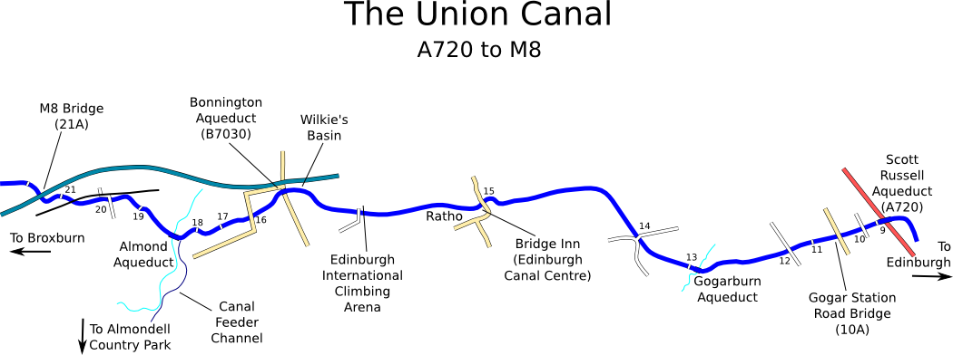
Map derived from data (c) OpenStreetMap
Beyond the ring road the canal is suddenly in the countryside, though the roar of traffic from the M8 to the north intrudes slightly. Buildings on both sides are replaced by fields, and there are numerous original stone arched bridges with their numbers on their keystones. (Within the city only one survived, but in the rural stretches almost all are still there). There is also a new bridge on this section - built in 1995 as part of the M8 extension work, some work obviously went into making it fit the canal surroundings, as it has an arch and a number. Unlike the original bridges, but like most of the newest bridges, it spans the full width of the channel rather than creating a narrow pinch-point as the older ones did.

Boat moored by bridge 10
By the time Gogar Burn is reached, the setting is even more rural and the motorway has diverged to the north a bit. A little stone aqueduct takes the canal across the burn. A couple of bridges further on, past a more sheltered stretch with trees, is the village of Ratho.
Ratho has always had a strong association with the canal, being the location of the first Staging Post. The canal was divided into four "stages" of roughly 8 miles each, and in the days of horse-drawn barges the horses were changed at the end of each stage. The staging post marking this division is still visible, next to an original milestone - these were placed at half-mile intervals along the canal, each giving the distances to Edinburgh and Falkirk. Most of the original milestones are still in place, and the missing ones were all replaced as part of the Millennium Link restoration work. The replacements are in the same style as the originals but can be distinguished by their paler coloured stone and much less worn appearance.
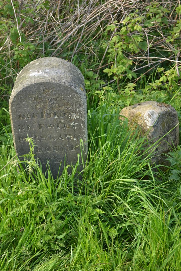
The milestone and staging post at Ratho
Ratho is also known for its canalside pubs. Legend has it that there was once a pub on the towpath side with a door at each end, so that the boatman could go in at one end, drink a beer on his way through, and exit through the far door in time to catch up with his horse and boat! Sadly this no longer exists, but another pub, the distinctive looking building on the offside by bridge 15, is still there and has played an important role in the regeneration of the canal: the Bridge Inn.
When Ronnie Rusack took over the pub in the early 70s, the canal was unnavigable and choked with weeds after decades of disuse and neglect. But he went exploring along it and was fascinated by this forgotten world, as well as immediately seeing its potential. Despite many difficulties, he succeeded in starting a restaurant boat operation from the Bridge Inn in 1974 - the first big boat to be used on the canal since its closure. Over the years, the original barge (The Pride of the Union) has been joined by many others and today Ratho is one of the busiest spots on the canal. As well as the Bridge Inn (now also known as the Edinburgh Canal Centre), it is also the main base for the Seagull Trust, a charity that operates free canal cruises for disabled people - their boathouse is on the offside beyond the pub and at least two of their bright red boats can usually be seen moored here.
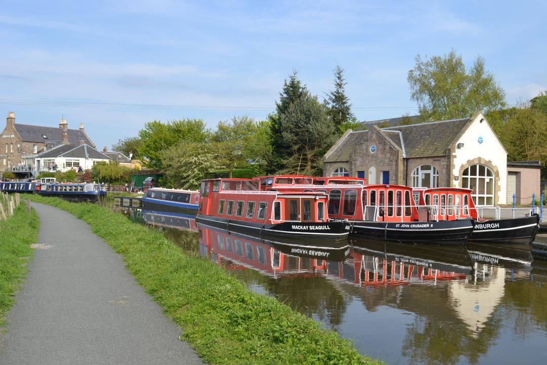
Boats at Ratho
Westwards from the village, the canal enters a picturesque wooded cutting. To the north are old quarries, and a newer development - the Edinburgh International Climbing Arena, whose access road crosses the water on a very high concrete bridge. As the canal emerges from the woods, the roar of the motorway is close by again. There is a basin, Wilkie's Basin, with an island in the middle, immediately followed by a metal trough aqueduct over the B7030. This aqueduct, known as the Bonnington Aqueduct, is notable because when built in 1978 (replacing the stone arched original) it was built to navigable dimensions - the first new road crossing since the canal's closure that didn't cause a blockage.
After the next bridge (16), the canal returns to wooded cutting. Bridge 17 is a larger and more circular arch than most, and in a very pretty setting. Beyond the next bridge, the waterway reaches the edge of the Almond Valley, where there are several things of interest. Firstly, the canal's main water feed enters on the south side. This comes from Cobbinshaw Reservoir several miles away, down the Bog Burn and the Murieston Water to "top-up" the River Almond. Then, in Almondell Country Park, a couple of miles upstream from here, the water leaves the Almond at a weir and flows down the valley in a little stream to join the canal. The feeder channel, like the main canal, has a path along it and this makes an interesting and rewarding walk through the country park and down the Almond Valley.
But more spectacular is the 5-arched Almond Aqueduct that carries the canal over the valley. It's smaller than the other two major aqueducts, the Avon and Slateford, but its lovely setting makes up for this. Like the Slateford Aqueduct, it has a sluice gate on top allowing water to be discharged into the river below when the canal's level is too high. This overflow famously froze solid in the exceptionally cold winter of 1895, creating a seventy-five-foot long icicle between canal and river, known locally as the Broxburn Icicle.
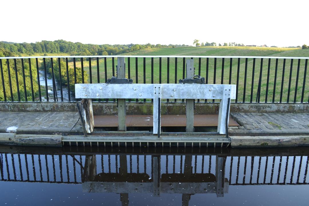
Sluice gate on Almond Aqueduct
The view down the river from the towpath of the aqueduct is quite interesting. The next bridge downstream is the M8 motorway crossing, but it is possible to make out the railway viaducts beyond that, and on a clear day even the Forth Bridges may be visible in the distance. The old building visible below is Lin's Mill; the aqueduct is sometimes referred to as the Lin's Mill Aqueduct.
The next stretch of canal is open countryside once more, with occasional bridges. Mostly these are the usual stone arches, but there is also a metal bridge carrying the Edinburgh to Bathgate railway line (which was electrified and re-opened all the way through to Glasgow in 2010), and soon after it is the M8 crossing. The motorway was built across the canal at water level in 1970, completely blocking the waterway and forcing towpath users to take a long and dangerous diversion. But like the other damage done to the canal after closure, this was put right by the Millennium Link project - in one of the biggest restoration jobs of the project, the canal has been diverted approximately 100 metres south to where the M8 is higher, and a new bridge (numbered 21A) put in, giving clear access through under the motorway. Lots of old canals have been blocked by motorways, but when the M8 bridge opened in 2000, the Union was the only canal in Britain to have had a motorway blockage subsequently removed.